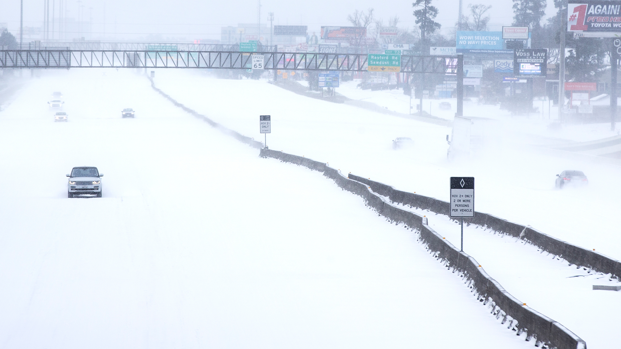
Despite rising global temperatures, winters across the Northern Hemisphere continue to bring brutal cold snaps and record-breaking snowfall. Events like the 2021 deep freeze that devastated Texas and Oklahoma, causing over $1 billion in damage, highlight a growing paradox: global warming and severe winter weather are not mutually exclusive. In fact, according to new research, they may be increasingly intertwined.
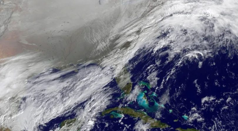
A study recently published in Science Advances reveals that dramatic changes in the polar vortex—a large zone of low pressure spinning above the Arctic—are becoming more frequent. These disruptions send frigid Arctic air plunging southward into Canada and the United States, fueling extreme cold spells. As the Arctic warms faster than any other region on Earth, these polar vortex shifts are becoming more pronounced and more frequent.
“Overwhelmingly, extreme cold and severe winter weather, heavy snowstorms, and deep snow are associated with these stretched events,” said study co-author Judah Cohen, director of seasonal forecasting at Atmospheric and Environmental Research and a visiting scientist at MIT.
Read More: Ancient Magnetic Crystals May Reveal Why Earth’s Magnetic Field Is Weakening
Understanding the Polar Vortex and Its Role in Winter Weather
The polar vortex is a persistent, swirling mass of cold air that typically remains locked above the Arctic. Under normal conditions, it behaves like a stable spinning top. However, when it becomes disrupted or stretched, pieces of this cold air can spill southward, triggering dramatic weather changes across the Northern Hemisphere.
Cohen and his research team studied over four decades of satellite data from the stratosphere—the atmospheric layer beginning about 12 miles (19 kilometers) above Earth’s surface—alongside historical winter weather records from 1980 to 2021. They identified five primary patterns of polar vortex behavior, two of which are strongly linked to deep freezes across North America.
Rather than complete collapses, which are rare, the polar vortex more often undergoes “stretch events”—a type of deformation that slings cold Arctic air toward the U.S. Midwest, Plains, and East Coast.
“It’s like a figure skater extending an arm while spinning,” Cohen explained. “The vortex stretches, distorts, and sends frigid air southward.”
Why Polar Vortex Stretch Events Are Becoming More Common
One of the most striking findings of the study is that these stretch events are occurring more often and more intensely. Since 2015, a specific stratospheric pattern—known for funneling Arctic air toward the U.S. East Coast and Midwest—has increased in frequency.
This trend appears to be influenced by La Niña, a recurring climate pattern characterized by unusually cool sea surface temperatures in the central and eastern Pacific Ocean. Multiple multiyear La Niña events over the last two decades may have reinforced certain polar vortex behaviors, making some parts of North America more vulnerable to prolonged winter cold.
“There’s been a noticeable shift in the type of stretch events,” Cohen noted. “Some patterns are now more dominant, and they tend to favor cold air outbreaks across key U.S. regions.”
Andrea Lopez Lang, an atmospheric scientist at the University of Wisconsin–Madison, who was not involved in the study, emphasized the practical value of these findings. Improved understanding of polar vortex dynamics could help meteorologists make more accurate medium-range forecasts.
“Knowing how the vortex behaves helps predict things like energy demand, insurance risks, and infrastructure vulnerabilities,” Lang said. “Will pipes freeze? Will power grids be able to handle the load? These are critical planning questions.”
Impacts on Forecasting and Future Climate Models
One of the most challenging areas for weather prediction is the two- to six-week window—a timeframe where current forecasting accuracy is relatively poor. The new research offers hope for improving this gap.
Cohen and his colleagues discovered repeatable patterns in how the polar vortex transitions between its five primary states. These insights may help meteorologists better anticipate cold outbreaks before they occur, especially if paired with real-time satellite data and advanced climate models.
“This paper can be really helpful in that shorter-range forecasting period,” Cohen explained. “If we can recognize the transition, we might predict the cold before it hits.”
The study’s implications go beyond immediate forecasting. As global temperatures rise, understanding how Arctic warming alters atmospheric patterns is crucial. Lang emphasized the need to explore how these polar vortex trends could evolve as the planet continues to warm.
How Arctic Warming Fuels Vortex Disruptions
At the core of this polar vortex instability is the rapidly warming Arctic. Cohen’s research shows that melting sea ice creates stark temperature differences between western and eastern Eurasia, which intensifies atmospheric wave patterns. These waves, in turn, distort the vortex, increasing the likelihood of stretch events.
Right now, one of the most influential atmospheric waves is driven by a warm ridge over Western Eurasia and a cold trough over the east. This wave amplifies the vortex disruption, especially during winter months when the jet stream weakens.
But what happens if Arctic sea ice vanishes completely?
“If the temperature gradient disappears, the wave pattern might collapse,” Cohen explained. “That could lead to a reversal in current trends—warmer winters in midlatitude regions and potentially a more stable polar vortex.”
Such a shift could align the Northern Hemisphere’s winter climate more closely with the Southern Hemisphere, where polar vortex disruptions are rare. That would likely mean less frequent extreme cold events across North America but could also mean fewer signals for medium-range forecasts.
Balancing Climate Narratives: Cold Snaps in a Warming World
The contrast between warming global averages and bitter winter cold often fuels public confusion and skepticism. How can the Earth be getting warmer if winter storms are getting worse?
This study helps answer that question by showing that warming in one part of the world—namely, the Arctic—can destabilize weather in another. It’s a reminder that climate change doesn’t simply raise temperatures uniformly; it also disrupts long-standing patterns and introduces greater volatility into weather systems.
“Climate change is increasing both heatwaves and cold snaps,” Cohen said. “They’re two sides of the same coin when atmospheric circulation becomes more chaotic.”
Implications for Infrastructure, Energy, and Insurance
From frozen pipelines to spiking energy bills and insurance claims, polar vortex events have real-world impacts. Understanding their increasing frequency can help industries plan more effectively.
Power grids in Texas, for example, weren’t designed to handle Arctic air plunges, leading to massive outages and costly damage in 2021. Predictive improvements, based on polar vortex modeling, could help operators prepare for such extremes in the future.
Similarly, insurance companies rely heavily on weather data to assess risk. With better insight into how often and where deep freezes might occur, they can refine coverage models, set premiums more accurately, and even incentivize weatherproofing investments in vulnerable regions.
“It’s not just about temperature,” Lang noted. “It’s about how weather interacts with infrastructure, insurance, agriculture, and even national security.”
Looking Ahead: The Future of Winter in a Changing Climate
As researchers continue monitoring the polar vortex, key questions remain. Will the patterns observed over the last 40 years continue? Could new climate feedback loops emerge as sea ice continues to melt? And how will long-term La Niña or El Niño cycles influence future vortex behavior?
The answers will be essential not only for weather forecasting but also for climate adaptation strategies worldwide. What’s clear is that even as the planet warms, winter weather will remain a dynamic and sometimes dangerous force—driven by changes at the top of the world.
Frequently Asked Questions
What is a polar vortex?
A polar vortex is a large area of low pressure and cold air that typically circulates around the Arctic. It acts like a barrier, keeping frigid air trapped in polar regions. When the vortex is disrupted or stretched, it can send Arctic air southward into the U.S., causing extreme cold.
How do polar vortex shifts impact U.S. weather?
When the polar vortex weakens or stretches, it allows cold Arctic air to spill into North America. This often leads to deep freezes, snowstorms, and unusually low temperatures in regions like the Midwest, Northeast, and Southern U.S.
Why are polar vortex disruptions becoming more frequent?
Rising Arctic temperatures—driven by climate change—are destabilizing the polar vortex. Melting sea ice and atmospheric changes are increasing the frequency and intensity of vortex disruptions, making extreme winter weather more common in mid-latitude regions.
Is climate change making winters colder?
While global temperatures are rising overall, climate change can paradoxically lead to colder winters in some regions. This is due to Arctic warming disrupting traditional weather patterns, including the polar vortex, which can push cold air southward.
Are these cold snaps related to La Niña?
Yes. La Niña patterns, which involve cooler ocean temperatures in the Pacific, can influence jet stream patterns and increase the likelihood of polar vortex shifts that bring cold air into the U.S.
Which areas of the U.S. are most affected by polar vortex events?
The Midwest, Northeast, and Plains states are most commonly affected, but extreme cold has reached as far south as Texas in recent years due to major polar vortex disruptions.
Can we predict polar vortex shifts in advance?
Thanks to improved satellite data and climate modeling, scientists are getting better at forecasting polar vortex behavior. While exact timing can be challenging, emerging research is helping to identify warning signs several weeks in advance.
Conclusion
The increasing disruptions of the polar vortex are a clear signal that climate change doesn’t just mean warmer temperatures—it also brings more extreme and unpredictable weather. As Arctic regions warm, the weakened polar vortex continues to push frigid air into the U.S., causing severe cold snaps in areas unaccustomed to such extremes. Understanding these atmospheric shifts is essential for improving weather forecasts, protecting infrastructure, and preparing communities for future winter extremes. As research continues, staying informed and proactive will be key to adapting in an era of growing climate volatility.